Parking has a significant impact on the intensity, pattern, and profitability of development. Better parking policies and applications are essential to developing communities that are vibrant and truly walkable. As communities attempt to catalyze densities critical to vibrant urban centers, it is helpful to understand the implications parking policies have on future development and redevelopment.
As the lead consultant for the Transportation Analysis for the Point of the Mountain, I recently worked closely with Ted Knowlton of the Wasatch Front Regional Council and other transportation partners to assess parking opportunities for the rapidly growing area surrounding the border between Salt Lake and Utah County, Utah. Among other things, we analyzed Floor Area Ratio (FAR) to demonstrate the land use density impacts of various parking ratios and parking configurations.
FAR is commonly used as a measure of density. It is calculated as the ratio of a building's gross floor area (which could include multiple stories) to the land area of the lot on which the building is located. Although the optimal FAR will vary by context, a ratio of at least 1.0 (where the building square footage is at least as much as the square footage of the land it sits upon) typically represents a strong urban setting.
The FAR estimates presented below for hypothetical parking rates and building stories demonstrate that increasing the building height alone has less impact on density than decreasing the number of parking spaces. For example, cutting the parking rate from 4 to 2 for a two-story building, increases FAR by 60% (from 0.43 to 0.69), while increasing the number of stories from 2 to 100 and retaining a parking rate of 4, increases FAR by 30% (from 0.43 to 0.56).
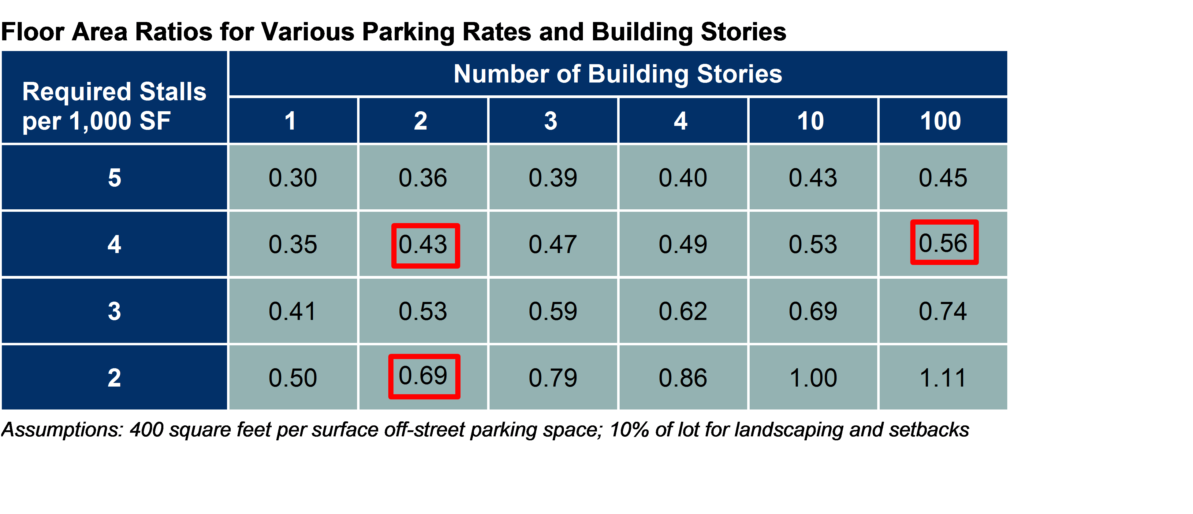
Because FAR represents the relationship between the building and the land on which the building is located, FAR values shown above would be the same for any building size, including a 20,000 square foot and 200,000 square foot building. This means that for any building size, 4 surface parking spaces per 1,000 square feet of building would allow for a FAR of about 0.5 for mid-rise buildings and slightly higher rates for high-rise buildings, both well below the 1.0 ratio representative of urban centers. Reducing to 2 surface parking spaces allows mid-rise and high-rise buildings to achieve FARs that are more representative of urban centers.
The FAR estimates presented below demonstrate the impact parking configuration (i.e., the type of structure and location of the parking facility) can have on densities. As highlighted in the table, the structured and underground parking configurations result in densities that are significantly higher than those for surface parking scenarios. Also, the results indicate that providing structured and underground parking have significantly more impact on density than the building height.
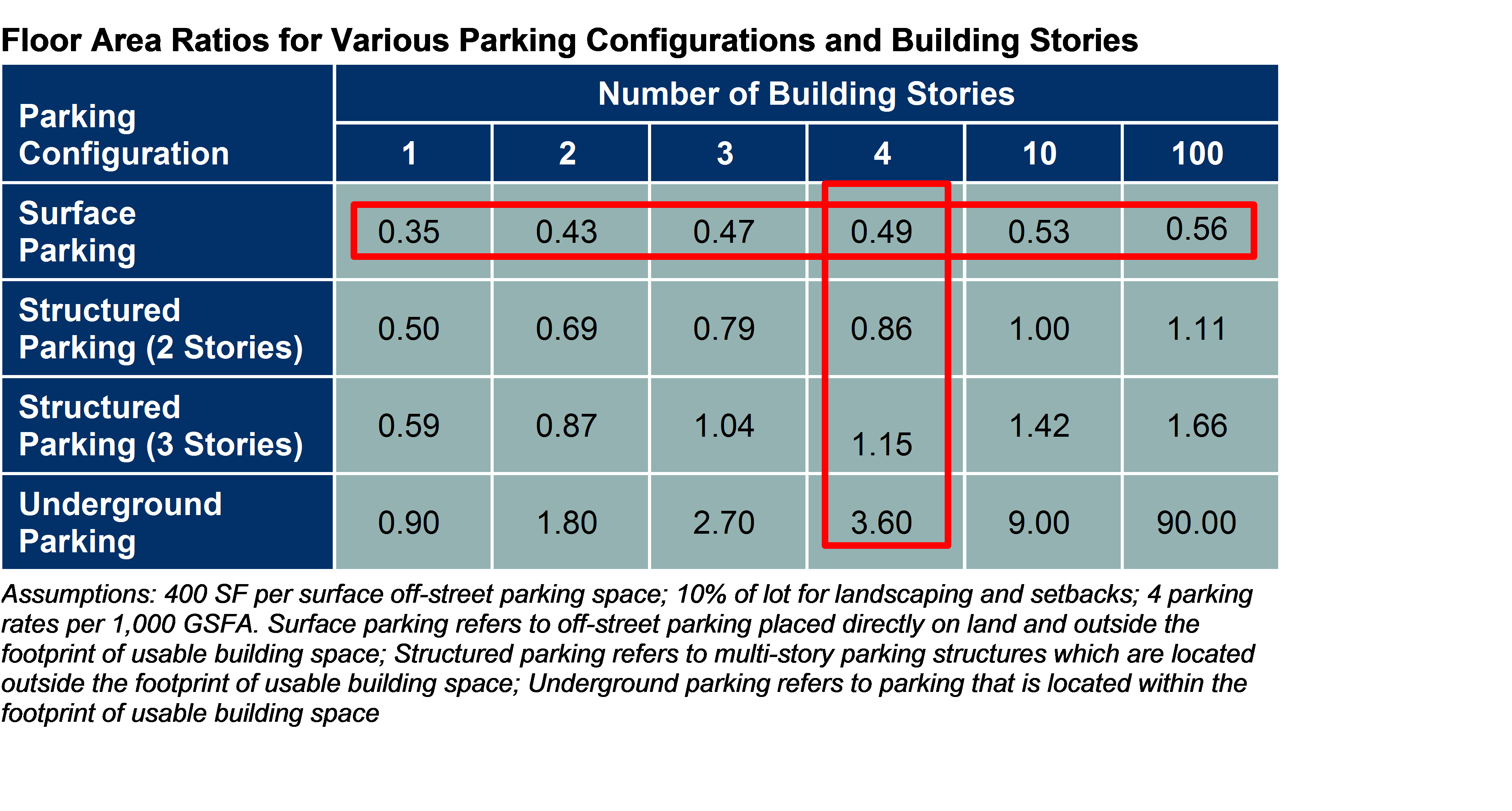
Although taller buildings are often attributed to increasing development densities, the scenarios presented above demonstrate that high parking rates and surface parking configurations overwhelm density advantages gained from increasing building height limits. In other words, increasing height limits without changing parking requirements does not provide densities needed for vibrant urban centers. The parking scenario calculations also demonstrate that higher density does not necessarily require high rise buildings.
In short, the FAR calculations above demonstrate the significant impact that parking policies can have on the density and typology of developments. They show that to achieve vibrant urban centers, local governments must consider better parking policies that reduce parking space requirements and promote structured parking configurations.
About the author: Diego Carroll is a board member of CNU Utah and is the founder of Monument Engineers, a Utah-based firm providing engineering, planning, and advisory services for transportation and community development projects. This article is a summary of a short memorandum prepared in May 2018 for the Point of the Mountain Transportation Analysis. The model used was developed by Ted Knowlton of the Wasatch Front Regional Council and is available by contacting Diego Carroll at .